Hubbard Scientific United States Classic Raised Relief | A True 3D Map You Can Feel the Terrain | Vaccum-formed Molded Map | 36'' x 24'' | Detailed Topography
Maps International Giant World Map - Classic Large World Map Poster - Laminated - 46 (h) x 77.5 (w)
MOVA Globe Relief Map Blue 4.5" with Base, Solar Powered Rotating Globe No Need of Battery or Chord, Unique Gift and Decoration
Raised Relief 3D Map of Israel (MEDIUM: 14.5 x 6.5)
USA map - 2D Giclée Print - 3D effect shaded relief Poster of the United States - Vintage Style 1871 America Elevation Map (180gsm Matt, 24 x 18 in)
World Ranger 3D Map by Hubbard Scientific | A True Raised Relief Map - You Can Feel the Terrain | Vacuum-formed Molded Map | 36'' x 24'' | Detailed Topography
National Geographic: United States, The Physical Landscape 1996 - Historic Wall Map Series - 31.25 x 20.5 inches - Paper Rolled
Alps relief wall map Georelief: Reliefkarte
Laminated World Odyssey Map Poster | Executive Style Map | Includes The Most Legible Location Labels | 36" x 24" | Shipped Rolled in a Tube, Not Folded | Great for The Home or Classroom
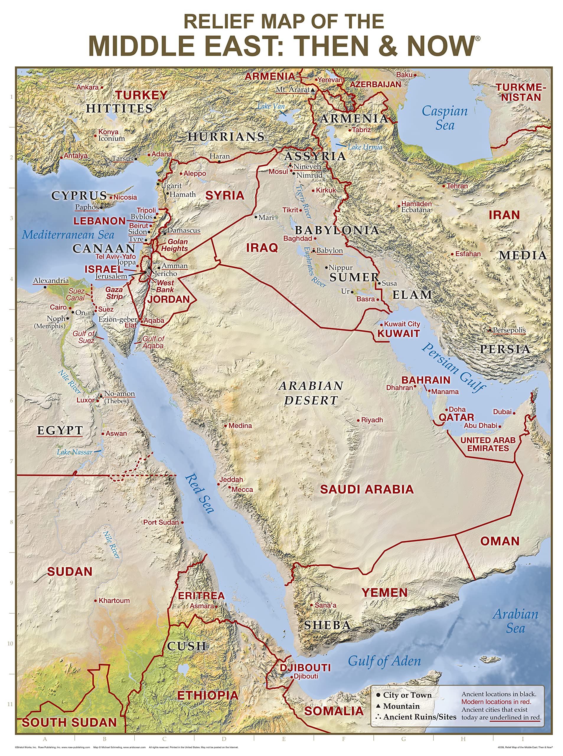
Middle East, Tubed: Wall Maps Countries & Regions
United States Classic Raised Relief | A True 3D Map by Hubbard Scientific - You Can Feel the Terrain | Vaccum-formed Molded Map | 36'' x 24'' | Detailed Topography
MOVAGlobe Relief Map Blue 6" with Base, Solar Powered Rotating Globe No Need of Battery or Chord, Unique Gift and Decoration
GELS Vintage Relief Map Poster Wales Map Decorative Painting Canvas Art Picture 16x24inch(40x60cm)
Hubbard Scientific 3D California Map | A True Raised Relief Map - You Can Feel the Terrain | Vacuum-formed Molded Map | 25" x 35" | Detailed Topography
Swiftmaps Africa Wall Map - GeoPolitical
Hubbard Scientific 3D United States Map | A True Raised Relief Map - You Can Feel the Terrain | Vacuum-formed Molded Map | 34.5″ x 22″ | Detailed Topography
Hubbard Scientific 3D Knoxville NI171 Map | A True Raised Relief Map - You Can Feel the Terrain | Vacuum-formed Molded Map | 32″ x 20.5″ | Detailed Topography
British Islands Geological Map - 3D effect relief Print (2D map with 3D effect using satellite terrain data) (200gsm SATIN, 32 x 24 IN)
Hubbard Scientific 3D San Francisco Bay SF2225 Map | A True Raised Relief Map - You Can Feel the Terrain | Vacuum-formed Molded Map | 22” x 25” | Detailed Topography
British Isles Map - bathy orographical - ocean depths and mountain heights Relief Map (200gsm Satin, 24 x 18 IN)
Reliefkarte Europa Gross 1 : 8 000 000: Tiefgezogenes Kunststoffrelief Map – 1 April 2011
Hubbard Scientific 3D United States Map | A True Raised Relief Map - You Can Feel the Terrain | Vacuum-formed Molded Map | 34.5″ x 22″ | Detailed Topography Map – Wall Map, 1 January 1993
Hubbard Scientific 3D North Carolina Map | A True Raised Relief Map - You Can Feel the Terrain | Vacuum-formed Molded Map | 38" x 19" | Detailed Topography
Hubbard Scientific 3D Great Smoky Mountains 403 Map | A True Raised Relief Map - You Can Feel the Terrain | Vacuum-formed Molded Map | 18.5″ x 12.5″ | Detailed Topography
Raised Relief 3D Map of Israel (MEDIUM: 14.5 x 6.5) Unknown Binding – Wall Map, 1 January 2017
3D Raised Relief Framed Map of USA - 12" x 9"
Hubbard Scientific 3D Texas 954 Map | A True Raised Relief Map - You Can Feel the Terrain | Vacuum-formed Molded Map | 28″ x 25″ | Detailed Topography
Relief Map Paperback – Import, 15 September 2017
Hubbard Scientific 3D Vermont & New Hampshire 959 Map | A True Raised Relief Map - You Can Feel the Terrain | Vacuum-formed Molded Map | 22.75" x 32.25" | Detailed Topography
Relief Map of the Middle East: Then and Now Wall Chart (Charts)
Relief Map of the Holy Land: Then and Now Wall Chart (Charts)
Hubbard Scientific 3D New Mexico NM1720 Map | A True Raised Relief Map - You Can Feel the Terrain | Vacuum-formed Molded Map | 17” x 20” | Detailed Topography
Historic Pictoric Wall Map, World - Ocean Floors and Land Relief. 1976 - Vintage Wall Art - 36in x 24in
Restoration Cartographic Washington State Restored Vintage Relief Map, Topographic Wall Art for the Home or Office, American States Series, 20 x 30 Inches
Construction of Maps in Relief. Illustrated
Muir Way - Tennessee 1977 Shaded Relief Map - Flat 2D Paper Print - Shaded 3D Illusion - Gallery Quality Fine Art Paper & Inks - 100% Cotton & Acid-Free - Made in USA - 40” x 12” 2D Print - No Frame
Hubbard Scientific 3D Alaska AK2421 Map | A True Raised Relief Map - You Can Feel the Terrain | Vacuum-formed Molded Map | 23” x 20.5” | Detailed Topography
The Relief of Kumasi. With 16 Illustrations and Plans and a Map
National Geographic World Ocean Floor - 42.5 x 29.5 inches - Paper Rolled
Muir Way - Idaho 1909 Shaded Relief Map - Flat 2D Paper Print - Shaded 3D Illusion - Gallery Quality Fine Art Paper & Inks - 100% Cotton & Acid-Free - Made in USA - 24” x 36” 2D Print - No Frame
Raised Relief 3D Map of Israel in Jesus' Time (Shows Place Names Under Roman Rule)
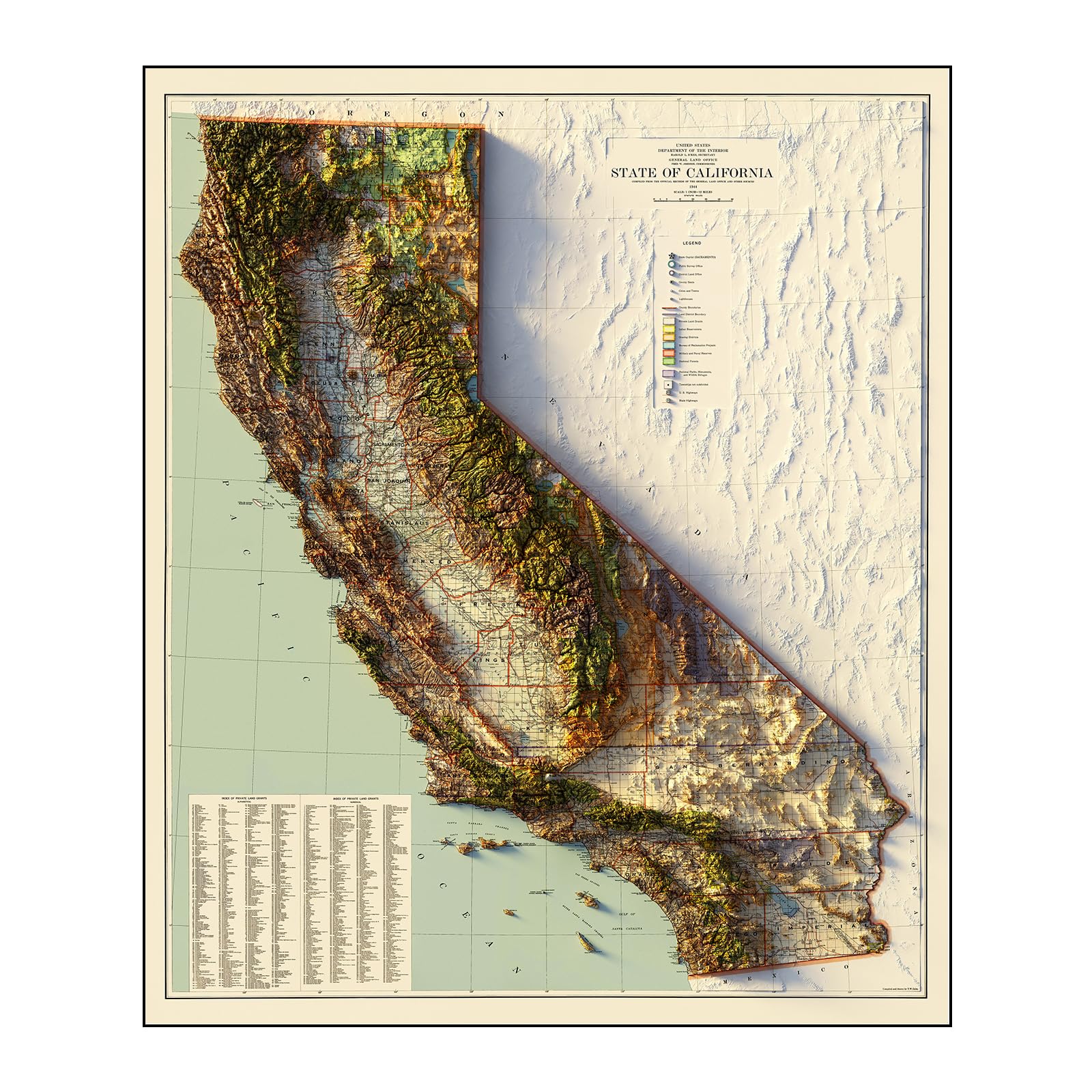
Muir Way - California 1944 Shaded Relief Map - Flat 2D Paper Print - Shaded 3D Illusion - Gallery Quality Fine Art Paper & Inks - 100% Cotton & Acid-Free - Made in USA - 42” x 49” 2D Print - No Frame
Relief Map of the Holy Land: Then and Now Wall Chart
Beibehang Exclusive BVZ0451 Golden Relief Qingming Shanghe Map Chinese Characteristic Culture Background Wall HD 3D Wallpaper(121 cm x 91 cm)
Muir Way - USA Geological 1932 Shaded Relief Map - Flat 2D Paper Print - Shaded 3D Illusion - Gallery Quality Fine Art Paper & Inks - 100% Cotton & Acid-Free - Made in USA -42” x 24”2D Print -No Frame
Hubbard Scientific 3D Yellowstone 419 Map | A True Raised Relief Map - You Can Feel the Terrain | Vacuum-formed Molded Map | 18.5″ x 25″ | Detailed Topography
Hubbard Scientific 3D Nevada NCR 2217 Satellite Map | A True Raised Relief Map - You Can Feel the Terrain | Vacuum-formed Molded Map | 22" x 17"| Detailed Topography
Holy Land New Testament Then and Now Relief Map (Charts)
Muir Way - Appalachian Trail 1981 Shaded Relief Map - Flat 2D Paper Print - Shaded 3D Illusion - Gallery Quality Fine Art Paper & Inks - 100% Cotton & Acid-Free - Made in USA - 24” x 36” - No Frame
OVANTO Scratch Off World Map & US Map-Durable 17x24” United States Map & World Travel Map with Pins & Accessory Set–Easy to Scratch Off Maps with Colored Details in Name-Tagged Gift Box for Travelers
72" W x 40" H - United States of America Wall Map - Extra Large - Features Shaded Relief Topography - Colorful, Decorative and Functional - Choose Paper or Laminated (both sides) (Laminated, 72" W x 40" H)
3D Raised Relief New York Framed Map - 12" x 9"
Hubbard Scientific 3D Cumberland NJ173 Map | A True Raised Relief Map - You Can Feel the Terrain | Vacuum-formed Molded Map | 31″ x 20.5″ | Detailed Topography
California Map 3D Raised Relief Framed Map Amazing Decorative Bird's-Eye View
Relief Map of the Holy Land: Then and Now Wall Chart
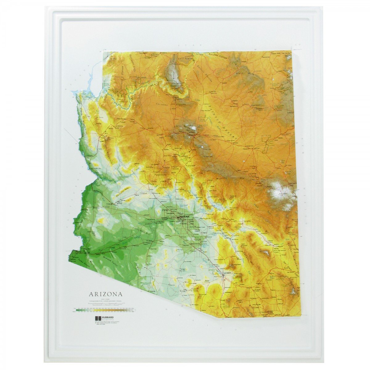
Hubbard Scientific Raised Relief Map 961 Arizona State Map
Muir Way - California 1977 Shaded Relief Map - Flat 2D Paper Print - Shaded 3D Illusion - Gallery Quality Fine Art Paper & Inks - 100% Cotton & Acid-Free - Made in USA - 24” x 26” 2D Print - No Frame
Muir Way - England & Scotland 1957 Shaded Relief Map - Flat 2D Paper Print - Shaded 3D Illusion - Gallery Quality Fine Art Paper & Inks - 100% Cotton & Acid-Free - Made in USA - 30” x 24” - No Frame
National Geographic New York Wall Map (40.5 x 30.25 in) (National Geographic Reference Map)
Rand McNally Signature Edition World Wall Map: Fol
Hubbard Scientific 3D Hawaii Map | A True Raised Relief Map - You Can Feel the Terrain | Vacuum-formed Molded Map | 36" x 24" | Detailed Topography
Muir Way - South America 1950 Shaded Relief Map - Flat 2D Paper Print - Shaded 3D Illusion - Gallery Quality Fine Art Paper & Inks - 100% Cotton & Acid-Free - Made in USA -24” x 32” 2D Print -No Frame
Muir Way - Iceland 1901 Shaded Relief Map - Flat 2D Paper Print - Shaded 3D Illusion - Gallery Quality Fine Art Paper & Inks - 100% Cotton & Acid-Free - Made in USA - 24” x 18” 2D Print - No Frame
Relief Map of the Middle East: Then and Now Wall C
Muir Way - Utah 1937 Shaded Relief Map - Flat 2D Paper Print - Shaded 3D Illusion - Gallery Quality Fine Art Paper & Inks - 100% Cotton & Acid-Free - Made in USA - 24” x 30” 2D Print - No Frame
National Geographic: United States Physical Wall Map (38.25 x 25.25 inches) (National Geographic Reference Map)
MOVA Globe Blue Relief Map 4.5"
Hubbard Scientific 3D Glacier National Park 416 Map | A True Raised Relief Map - You Can Feel the Terrain | Vacuum-formed Molded Map | 18.5” x 24.5” | Detailed Topography
World Decorator, Laminated: Wall Maps World
Restoration Cartographic Greece Minimalist Relief Map, Topographic Wall Art for the Home or Office, Minimalist Series, 12 x 18 Inches
Relief Map Earth, Snapspheres Magnetic 7.3" Globe, with Geology Map Interior, with Stand
Smithsonian Journeys 30x48 World Wall Map - Blue Ocean Edition (30x48 Laminated) Unknown Binding
Swiftmaps Europe Wall Map GeoPolitical Edition SM EUR SM L
Map of China & Relief Topographical Map of China(Chinese Version) 1:11 400 000 Laminated Double-Sided Waterproof 57x43cm
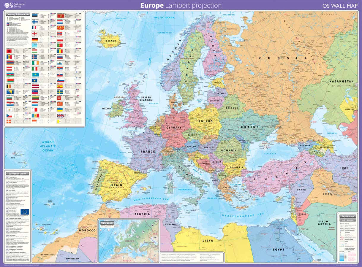
Europe: Lambert projection Map – 12 March 2020
Atlas & Green Scratch Off World Map Large 70x42cm | Ultra Detailed World Map Poster - All US States. Scratch Map World Accessories Kit Gift Tube. Travel Journal Wall Art - Deluxe Cartographic Map
World Executive, Poster Size, Tubed: Wall Maps World
National Geographic: Africa Classic Political Wall Map - Extra Large - 35.75 x 46.25 inches - Art Quality Print
Construction of Maps in Relief. Illustrated
World Physical Sea Relief Map 1:35,000,000
National Geographic Maps Australia Classic, Tubed: Wall Continents
TECNODIDATTICA World Map Atmosphere Relief Rilievo
Exerz32Cm Relief Illuminated Ar Globe With Cable Free Led Light- Physical/Political Dual Map- Augmented Reality App Ios Android - Light Up Globe
Restoration Cartographic Mexico Minimalist Relief Map, Topographic Wall Art for the Home or Office, Minimalist Series, 20 x 30 Inches
South of Kings Gall Orthographic World Map | Most Accurate World Map - Countries are Shown in Correct Proportion to Each Other | Laminated World Map | 36” x 24”
Topanga State Park Trail Map: Topanga, Will Rogers, Tuna Canyon, Backbone Trail, Red Rock Canyon, Temescal Gateway: Shaded-Relief Topo Map (Tom Harrison Maps)
HUBBARD SCIENTIFICHUBBARD SCIENTIFIC AMERICAN EDUCATIONAL PROD 432 - United States Relief Map - United States Relief Map - Each
Stainless Steel Acupressure Massage Stick with Reflexology Map Socks and and Gloves Tool Set – Manual Trigger Point Therapy for Foot Pain Relief, Deep Tissue Meridian Massage, Men Size, Green
Insight GuidesInsight Guides Travel Map Switzerland
National Geographic World Physical Wall Map (45.75 X 30.5 In) Map – 1 January 2018
England South West relief wall map A4 gift box
Altitudes in the Dominion of Canada With a Relief Map of North America
Canada Classic, Tubed: Wall Maps Countries & Regions
Charlesbridge Publishing Sir Cumference and the Viking's Map
Swiftmaps SM WOR PREM EL SM LAM World Premier Wall Map Poster Mural 24h x 36w Laminated


![World Map [Folded]](https://m.media-amazon.com/images/I/81ef0jrm6oL.jpg)